


Magnetotellurics (PhD-Project Alexander Löwer)
Magnetotellurics in the Vogelsberg/Wetterau, Hesse, with 3D anisotropic modelling of the conductivity structures
The Vogelsberg is the largest volcanic region in Central Europe with an area of 2500km². Huge amounts of slag, tuff and lava were extracted by many small volcanos during its active phase about 16 million years ago and have formed a large basalt layer. This covers the Phyllitzone (PZ) and Mid-German-Crystaline-Rise (MGCR), which marks the border between the Rhenohercynian and the Saxothuringian. Hence, their exact extension beneath the Vogelsberg region could not be verified by drillings yet. The structural fabric in this zone is correlated with the variscan SW-NE strike direction. Another fault within the investigation area is the Horloff-Graben, which is a prior extension of the Upper-Rhine-Graben and crosses the previous geological structures with a NNW-SSE strike.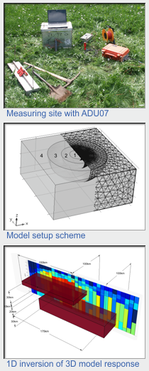 Recent seismicity signifies a weak active fault zone which is reaching the middle crust. In the southwest Vogelsberg area plenty mineral and thermal waters appear whose origin is under controversial discussion.
The conductivity structure beneath the Vogelsberg area was investigated with the magnetotelluric method. This method uses natural time depending variations of the earth’s electric and magnetic field. Its responding to conductivity contrasts beneath the surface which might be for example free fluids or partial melts. The PZ and MGCR are supposed to have anisotropic conductivity structures and should therefore be differentiable from the bedrock and the sediment covering of the Horloff-Graben. The targets of these studies are the differentiation and search for the extension of the geological structures beneath the Vogelsberg basalt and their importance for the exploration of hydrological and geothermal resources.
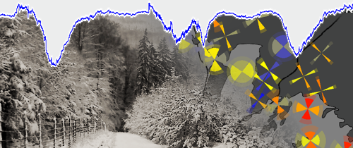
A 3D array with 25 broadband magnetotelluric stations was set up during winters 2010/11 and 2011/12 in an area south west of the Vogelsberg with a lateral dimension of about 800km². Thus, it is covering the Holroff-Graben and the PZ / MGCR boundary. The stations recorded natural time variations of the Earth’s electric and magnetic fields in a broad band period range from 0.1ms to 10,000s using Frankfurt’s GEOLORE system and Metronix ADU 07.
Due to Germanys high population density a low signal to noise ratio was assumed and confirmed by the measurements. Therefore, extensive studies on digital signal processing have been carried out during the data processing in order to reduce the effect of signals originating from an anthropogenic source.
To reconstruct the earth’s conductivity structures, various modelling studies basing on the Phasetensors and vertical magnetic transferfunctions were performed. These were done by 3D- forward modelling interface which was developed during this project and is based on the COMSOL Multiphysics environment. This program is able to compute the effects anisotropic conductivity structures of arbitrary complexity. In Addition, an isotropic 3D inversion was done using ModEM.
Recent publications:
- Löwer, A. (2014): Magnetotellurische Erkundung geologischer Großstrukturen des südwestlichen Vogelsberges mit anisotroper, dreidimensionaler Modellierung der Leitfähigkeitsstrukturen, PhD-Thesis, Goethe-Universität Frankfurt
- Löwer, A., Junge, A., Tietze, K. (2013): (An)isotropic 3D Array Magnetotelluric Modeling of the South Western Vogelsberg Area, Poster, 46th AGU Fall Meeting, San Francisco
- Löwer, A., Junge, A. (2012): Horloffgraben und Mitteldeutsche Kristallinschwelle: 3D Array Magnetotellurik im südwestlichen Vogelsberg, Poster, 72nd annual Meeting DGG, Hamburg
- Löwer, A., Junge, A. (2011): Phyllitzone und Horloffgraben: Magnetotellurik im südwestlichen Vogelsberg, Poster, 71st annual Meeting DGG, Cologne
- Löwer, A. (2009): Audiomagnetotellurik im Hohen Vogelsberg, Diploma-Thesis, Goethe-Universität Frankfurt
Project contact: Alexander Löwer